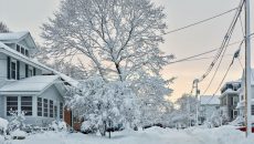
Remember last winter? When it seemed like it would never end? Snowstorm after snowstorm buried Massachusetts.
Frank Colby is an atmospheric science professor and a lead expert in weather. He explained why we saw an extraordinary winter. “It depends a lot on the position of the jet stream,” said Colby. The jet stream got stuck last year.
The jet stream is a narrow, variable band of very strong, predominantly westerly air currents encircling the globe several miles above the earth.
The jet stream controls how cold it gets. It also controls where storms form.
There is a polar jet stream from Canada, as well as a southern jet stream in the southern parts of the United States.
For the past couple of winters, there was a Ridge of high pressure over the west coast. This brought dry and warm conditions towards California and the Southern Plains. On the east coast, there was a troughing low-pressure system that brought cold and snow.
The jet stream did not move last year however, it got stuck into a position that allowed storms to form one after another. There are always waves of energy in upper atmosphere, allowing storms to form and get drawn down.
Colby expects a cold pattern for the next two to three weeks. We are now in a pattern that is favorable to winter weather, as waves of energy have transferred into the stratosphere, weakening the polar vortex from above forcing cold air to meander towards New England.
Colby does not expect a repeat of last year. The trough and cold air location is different this year than that of last year. New England will continue to be on the edge of where the heaviest snow will be.
Colby is expecting a cold and dry pattern. However, a big snowstorm is not ruled out as Mother Nature is known to throw curveballs in our direction.
David Coe, a graduate student in atmospheric science expects a different scenario than Colby. Coe expects a cold pattern within the next two weeks. He believes that the best chance of seeing any winter weather is from now until the end of February.
Coe also expects a spring like transition with more mixed precipitation by the end of February and into the start of March.
Nick Buck, also an atmospheric science student expects a cold pattern for the next two weeks.
The good news for non-snow lovers is that, they probably will not be buried in copious amounts of snow this year.